| |
| Greathouse Point > Greathouse Archives > USA > WV > Monongalia County | ||||||
Greathouse of Monongalia County, WV
Do you have any Greathouse kith and kin who resided in Monongalia County, WV? If so, please join us in our efforts to better document the Greathouse kith and kin who lived in this county, by sending your additions and corrections to Greathouse Point.
1781, Oct 6 - Land Entry/Survey/Grant: Joseph Tomlinson, Jr., 600 Acres, Letart
1781, Oct 6 - Land Entry: Joseph Tomlinson, Jr., 600 Acres, Letart
We the Commissioners for adjusting Claims to Unpatented Land in the Counties of Monongalia Yohogania and Ohio do hereby Certify that Joseph Tomlinson Jun.r is Intitled to Six hundred Acres of Land in Monongalia County in right of Preemption adjoining his Settlement made in 1773 on the Ohio River Opposite Latorts Fall Given under our hands at Samuel Lewellins this 6th of October 1781. John P. Duvall Test John Evans Clk. Com. Entered 9th October 1781.
1783, Sep - Land Survey: Joseph Tomlinson Jr., 500 Acres, Letart
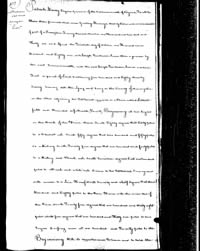
Sept. 1783 Surveyed for Joseph Tumblestone [Tomlinson] Junr. 500 Acres of Land in Monongalia County on part of a Land Office preemption Warrant of 600 Acres No. 1631 Dat'd the 20th of Octbr. 1781 Entered the 22d of March 1782 on the Ohio Adjoining his Settlement Opposit Letarts falls and bounded as follows Viz. Beginning at two sugar tree on the Bank of the River thence S 83 W 60 poles to a Chestnut Oak S 50 W 250 Poles to a Hickry S 25 W 140 poles to a Hickry & Black Oak S 17 E 10 Poles to a Beach and White oak Corner to his settlement Survey and with the Reverse to a Line thereof N 70 1/2 degrees W 380 Poles to the River Thence with the Meanders of the River N 24 W 138 Poles N 5 W 136 poles to two Sugar trees Crossing a run at 120 poles to the Beginning. Platted by a scale of 100 poles to the inch } No Variation. David Seare [Sayre] } Thos. Evans } Sworn Chain Bearers. George See Assistant to Sam'l Hanway S.M.C [Surveyor Monogalia County] Footnotes:
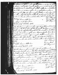
1785, Apr 25 - Land Grant: Joseph Tomlinson Jr., 580 Acres, Letart Joseph Tomlinson, 580 acres, Monongalia, Examd.
Patrick Henry Esquire Governor of the Commonwealth of Virginia, To all to whom these presents shall come, Greeting: Know ye, that by Virtue and in consideration of part of a Preemption Treasury Warrant Number one Thousand six hundred and Thirty one and Issued the Twentieth day of October one Thousand seven Hundred and Eighty one unto Joseph Tomlinson Junior there is granted by the said Commonwealth unto the said Joseph Tomlinson Junior a certain Tract or parcel of Land, containing five hundred and Eighty acres by Survey bearing date the lying and being in the County of Monongalia on the Ohio adjoining his settlement opposite to a place call Lettarts falls and Bounded as followeth, To wit, Beginning at two sugars on the Bank of the River thence South Eighty degrees West Sixty poles to a Chesnut Oak South fifty degrees West two hundred and fifty poles to a Hickory south twenty five degrees West one hundred and forty poles to a Hickory and Black Oak South Seventeen degrees East one hundred poles to a Beach and white oak Corner to his Settlement Survey and with reverse to a Line Thereof North Seventy and a half degrees West three hundred Eighty poles to the River Thence with the meanders of the River North Twenty four degrees West one hundred and thirty eight poles North five degrees West one hundred and thirty six poles to two Sugars crossing a run at one hundred and Twenty Poles to the Beginning P. Henry
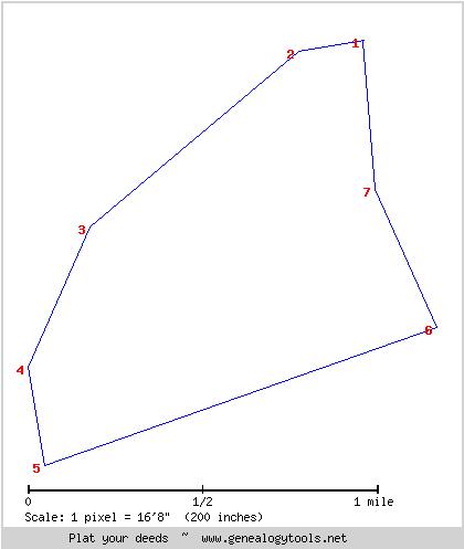
Excerpt from Metes and Bounds Prepared and Revised for Use with Deed Platter: S 80 W 60 Excerpt from Metes and Bounds Prepared with Deed Platter Revisions for Transfer to Google Map: Beginning at two sugars on the Bank of the River thence South Eighty degrees West Sixty poles to a Chesnut Oak S 80 degrees W 60 poles South fifty degrees West two hundred and fifty poles to a Hickory S 50 degress W 250 poles south twenty five degrees West one hundred and forty poles to a Hickory and Black Oak S 24 degrees W 140 poles South Seventeen degrees East one hundred poles to a Beach and white oak Corner to his Settlement Survey S 10 degrees E 92 poles and with reverse to a Line Thereof North Seventy and a half degrees West three hundred Eighty poles to the River N 70.5 degrees W 380 poles Thence with the meanders of the River North Twenty four degrees West one hundred and thirty eight poles N 24 degrees W 138 poles North five degrees West one hundred and thirty six poles to two Sugars crossing a run at one hundred and Twenty Poles to the Beginning N 5 degrees W 136 poles crossing a run at 120 poles
Sources: Monongalia County, WV, Claims to Unpatented Lands, Microfilm, Page 370, 1781, Oct 18 - Land Entry: Joseph Tombleson, 600 Acres, Letart. View Entry @ Fold3 Monongalia County, WV, Survey Records, Book 3, Page 26, 1783, Sep - Land Survey: Joseph Tomlinson Jr., 500 Acres, Letart. View Survey @ Fold3 Greathouse Point, Greathouse Archives, USA - Mason County, WV. Mapping Big Mill Creek, 1780-1820: Early Landowners of Letart, Millwood and Evans, West Virginia Virginia State Land Office. Grants A-Z, 1-124, reels 42-190; Virginia State Land Office. Grants 125- , reels 369-. Land Office Grants O, 1785, p. 457 (Reel 55). 1785, Apr 25 - Land Grant: Joseph Tomlinson, 580 Acres, Letart. View Grant @ Fold 3 [ Page 457 | Page 458 ] |
||||||
Disclaimer All information submitted to this site remains to the extent the law allows, the property of the submitter who, by submitting it, agrees that it may be freely copied, but never sold or used in a commercial venture without the knowledge and permission of its rightful owner. |
||||||
 |
 |
|
Copyright © 1998 - 2011, Greathouse Point. Terms of Use | Privacy Policy | Site Map |